Eastern Pacific's First Cat 5 of 2026: What Fueled Its Surge?

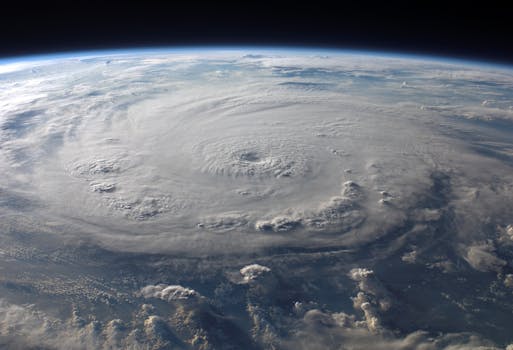
Hurricane Genevieve dramatically intensified into the Eastern Pacific's first Category 5 storm of 2026, reaching 160 mph winds in just three days. While fortunately staying clear of land, its rapid ascent highlights a worrying trend. Exceptionally warm sea surface temperatures, amplified by an early and powerful El Niño, created ideal conditions for this intense storm. This event serves as a stark reminder of how our changing climate contributes to more powerful and rapidly developing hurricanes, emphasizing the urgent need for environmental action to mitigate future risks.
Genevieve's dramatic transformation from a tropical depression to a Category 5 hurricane in just three days is a significant event. This powerful storm, hitting 160 mph, drew its immense energy from vast stretches of unusually warm ocean water, with temperatures around 86°F (30°C). These near-record warm conditions across the tropical Eastern Pacific, particularly amplified by an early and strong El Niño event, provided the perfect fuel for such rapid strengthening. Though Genevieve is predicted to weaken and remain harmlessly far from populated areas, its formation is a clear signal of the powerful connection between ocean warmth and extreme weather.
This year alone, Genevieve marks the fourth Category 5 tropical cyclone globally. Previous powerful storms like Super Typhoon Sinlaku 185 mph (295 km/hr) winds, which caused significant damage and loss of life, and other intense typhoons, underscore the potential for widespread destruction when such storms make landfall. Notably, powerful tropical cyclones have hit U.S. states or territories with increasing frequency, matching the number of Category 4 and 5 landfalls from the previous 60 years in just the last decade, as noted by NOAA's HRD. These events serve as potent reminders of the devastating consequences of our warming planet and the critical importance of global climate action.
Meanwhile, Hurricane Fausto is also making its way across the Pacific, passing north of Hawaii. While Fausto is weakening due to drier air and cooler waters around 77°F (25°C), it still brings gusty winds and high surf of 10-15 feet to the Hawaiian islands. Further west, Tropical Storm Dolphin is anticipated to follow a similar path of intense development, with the Joint Typhoon Warning Center predicting it could become another Category 5 typhoon by late this week in an unusually aggressive forecast, again fueled by warmer-than-average ocean temperatures. These successive powerful storms illustrate the pressing need to embrace sustainable solutions and accelerate electrification efforts, moving away from fossil fuels that contribute to the ocean warming trends driving these extreme weather patterns.